Master student Florian og undertegnede fra UiT’s geofare-lag dro forrige uke på den 37. Nordiske geologiske vinter møte, som i år ble holdt i Turku (eller Åbo), Finland. The Nordic Geological Winter Meeting er som navnet tilsier en konferanse for geofag i Norden. Det arrangeres annet hvert år og er et veldig artig møtested og en god kilde til inspirasjon!
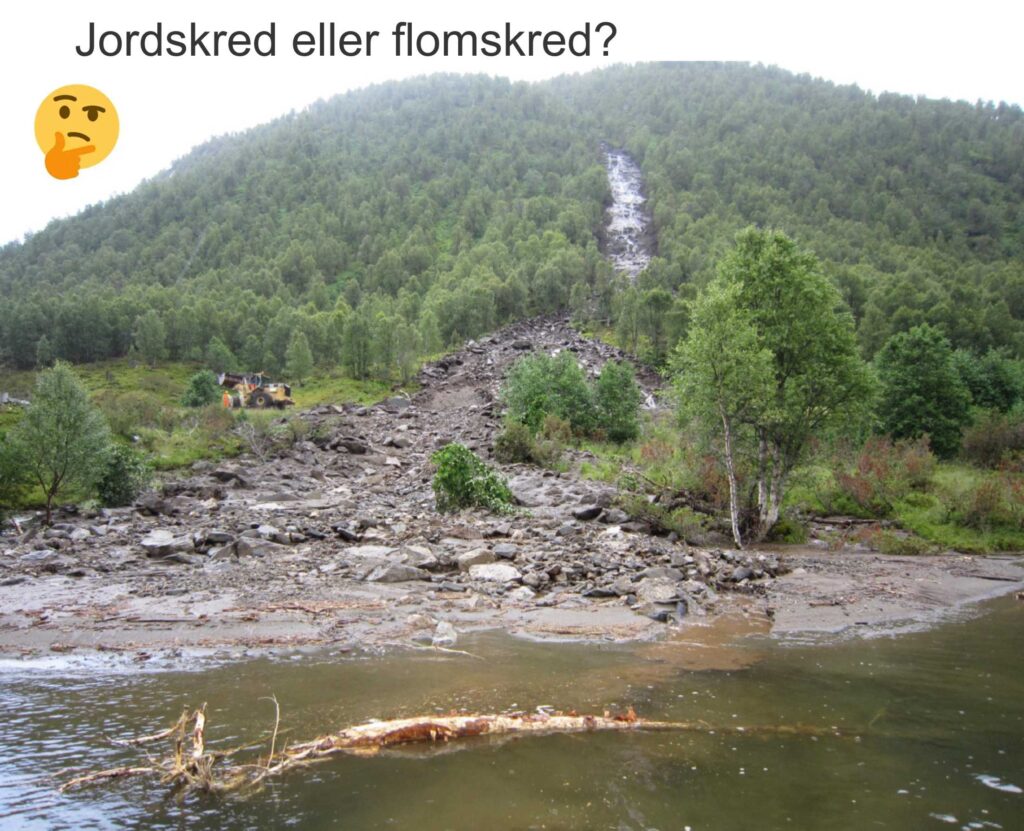
Flom eller skred, jord eller vann?
Det er kommet et nytt forslag til felles norsk terminologi for jord- og flomskred fra forskere ved Høgskulen på Vestlandet (publisert i Norwegian Journal of Geology). Målet er å rydde opp i tidligere uklar og upresis definisjon av massebevegelse (skred) i løsmasser. De prøver å gi et klarere og mer presist språk som beskriver hvordan massene faktisk beveger seg – i tråd med den internasjonale klassifikasjonen. Dette har gitt frustrasjon til mange som arbeider med faget, og spesielt for studenter som er forvirret til definisjoner og sammenligning til internasjonale definisjoner. Publikasjonen er god timing for oss på UiT som for tiden arbeider med ulike typer skred i Geohazards (GEO-2012).
Fra felt til lab på Gámanjunni-3: prøver fra skjærsoner i tåa
Med værvindu og en plan for kartlegging på det ustabile fjellpartiet Gámanjunni-3 flyr vi helikopter for å samle inn prøver til numerisk modellering.
Continue reading Fra felt til lab på Gámanjunni-3: prøver fra skjærsoner i tåaSkredsommer
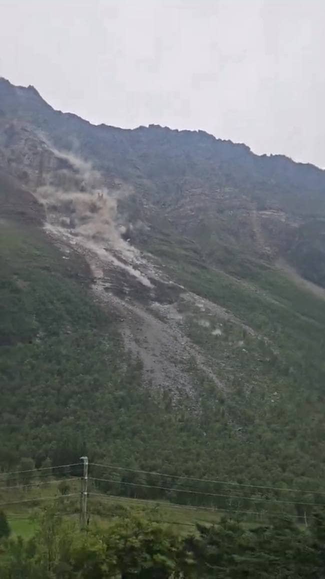
I sommer har det vært aktivitet i fjellpartier både nord og i sør. Skredaktiviteten har stort sett vært steinsprang av større og mindre omfang som har pirret turister og skremt lokale.
Høyaktuell oppstart for geofarestudenter
Det er snart klart for oppstart av et nytt semester ved IG. Sommeren har vært interessant i et geofareperspektiv: det har vært høy aktivitet i fjellpartier rundt om i landet, det har vært hetebølger, styrtregn og jordskred. Alle disse er hendelser som kan bli høyaktuelle for høstens emne i geofarer.
Continue reading Høyaktuell oppstart for geofarestudenterNår et fjellskred roterer seg fast
Dette er Andreas Grumstads bidrag til geoforskning.no sin formidlingskonkuranse 2024.
Fjellet står der. Vi sier gjerne at fjellet står. Hvis vi sier at fjellet ligger antyder det at det kanskje ikke vil falle. Fjellene står der rundt oss, over hele landet. Og fjellet kan falle ned, i hvert fall deler av fjellsiden kan rase ut. Når deler av fjellene faller, kaller vi det fjellskred. Fjellskred har store volum, over 100 000 til titalls millioner kubikkmeter og går over hele dalbunnen og oppover motstående dalside. Det er spesielt ustabile fjellsider som kan kollapse ned i fjord eller innsjø og skape tsunamier som kan være spesielt ødeleggende for oss mennesker og infrastruktur.
Continue reading Når et fjellskred roterer seg fastTo sesonger med skredtårn i Grøtfjord.

Stengte veier og utsatte strekninger er vanlig kost for innbyggere i Troms fylke. Det er omtrent 100 lokaliteter langs veinettet der snøskred ofte påvirker trafikken. Troms fylkeskommune han ansvar for alle fylkesveier som er på totalt 3048 km. Målsetningen til fylkeskommunen er ingen skred på åpen vei, lav stengetid og høy forutsigbarhet. I Grøtfjorden november 2022 startet drift av den første vegstrekningen i Troms med skredtårn.
Continue reading To sesonger med skredtårn i Grøtfjord.Landslide geosite series; geosite 4: Langfjordura, Arnøya

Oldefar fjellskred i Troms? by Andreas Grumstad
Geosite type: Fjellskred avsetning.
Kooridinater: 70.1411309, 20.5479644
Distanse fra Tromsø: Underkant av 5 timer med bil fra Tromsø til Langfjorden på Arnøya inkl ferge mellom Storstein og Lauksundskaret. Parkering midt i avsetningen.
Kor e det? Norgeskart, Google Maps
Continue reading Landslide geosite series; geosite 4: Langfjordura, ArnøyaMasterarbeid i Seidi
Fabrice Kaltenrieder er masterstudent ved IG og arbeider med fjellskredet Seidi til sin masteroppgave.
Seidi er et ustabilt fjellparti som ligger i Sørfjorden, ca. 10 minutter fra Lakselvbukt i Tromsø kommune. Seidi er et nedsunket fjellparti som ligger mellom toppene 1060 og 1046 moh på vestsiden av Sørfjorden. Det strekker seg fra ca 848 moh og ned til fjorden, muligens under havoverflaten og er c. 1.3km bredt ved bunnen. Generelle bevegelses data fra InSAR norge viser at fjellsiden beveger seg opp til 4 cm i året helt øverst og et parti ved fjorden mot nord. Hele Lakselvdalen har relativt mye ustabil skråningsaktivitet, blant annet Laksvatnfjellet (se Rasmussen (2011)). Skråningen på motsatt side av dalen som vender mot vest, der Piggtindmassivet ligger har flere ulike former for ustabiliteter som er undersøkt av tidligere mastersudent Henrik Sandbakken (2021). Vi kan anta at bergrunnen er gangske lik for Seidi og Piggtind massivet, og ettersom det er bevegelser i begge dalsider (som vender mot hverandre) er det interessant å undersøke Seidi for å sammenligne.

Landslide geotourism series. Geosite 3: Skredkallen
by Andreas Grumstad
Geosite type: Fjellskred og ustabilt fjellparti.
Kooridinater: 70.171925, 19.865965
Distanse fra Tromsø: Det er ca 2,5 time kjøretur fra Tromsø inkl en fergetur til parkering. Fergen er Hansnes-Vannøy. Etter dette kjører man til turparkering i Kristoffervalen. Derfra er det drøyt 1,5 gange på sommerføre.
Kor e det? Norgeskart Google Maps Stien starter her
